ELECTRIC
GIS is widely used in the field of electric utilities, from electricity network visualization to real-time status of the assets to fault management and the efficient solution for clients. CartoSolution provides wide range of GIS solution from consulting and understanding the requirements of clients. Our solution stretch the entire chain from legacy records conversion and offline online management, to aiding mission critical requirements and system process for electric distribution and transmission networks.
Cartosoluton’s main advantage is to incorporate strong domain knowledge with technical knowhow. Our solutions are endorsed by seasoned domain expertise in consulting, analysis, design and deployment of enterprise solutions. Knowing that the electricity distribution system goes through miles of power lines joining the substation to end user, and we believe its very crucial to map and visualized the network on various platforms.
Asset Records management
- Records conversion
- Data integration
- Primary / Secondary connectivity
- Reactive change-out
- Field order forms update
Enterprise GIS
- Data Migration
- Data model / system design, development and integration
- Application development
Data management
- Network drafting
- T&D Network Mapping
- GIS Data consolidation
- Work order processing and position into GIS
- Legacy data conversion and migration
- Station modeling
- Geo Schematics configuration
Records Management
Main data building goals include streamline process to create complete, accurate, and robust information about electrical and civil assets timely basis
CartoSolution strengthen the client’s asset data records into a known GIS database. Key solution included transforming maintenance schedule forms in GIS environment, AS built drawings verification and entering in document management system, vectorizing, error correction, and validating electrical and civil primary / secondary connectivity in database, and maintaining underground cables in GIS, overhead legacy feeder layout conversion, and incorporating missing cross reference between core database for asset condition assessment (ACA) and non-ACA assets.
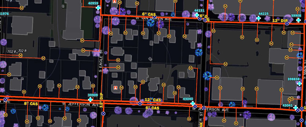
Network data unification and Geo-schematic configuration
The requirement of ensure consistency between GIS database, CAD drawing, and build a geodatabase from raster-vector or any other form of information. CartoSolution developers build various API’s to enable the data to flow in all directions, creating and updating data in any system that have integrated together.
Find More...
Network data unification
Geo-schematic configuration
- year-on-year efficiency dividend
- Control total cost of ownership
- Rapid transition processes to achieve reliable operations
- Rethink vs replicate existing processes
- Optimized infrastructure usage
- Robust project management systems
- Flexible team capacity